Saturday, January 31, 2015, 12:00 pm
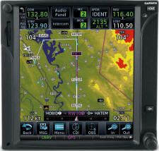
Cockpit technology is becoming more sophisticated and more accessible, which is good news for GA pilots. When used properly, these tools increase our safety in the skies exponentially. One new category of information available to GA pilots is terrain awareness. Terrain Awareness and Warning Systems (TAWS) can vary from simple display of ground elevations to active alerting systems that warn when AGL drops below certain minimums. Newer GPS navigators, including many G1000 displays, include fine-grained displays of terrain and obstacles that can greatly improve the pilot's situational awareness, provided their capabilities and limitations are understood. The goals for all of these systems are to better inform the pilot about terrain separation and to prevent controlled flight into terrain (CFIT) accidents.
In this seminar, we define and examine the common database-driven terrain awareness functions: basic color-coded terrain and enhanced awareness via TAWS-B. Basic terrain awareness compares the aircraft's altitude and GPS position with detailed underlying 3D maps of terrain and obstacle elevations. TAWS-B adds to this a predictive estimate of aircraft trajectory and audible annunciations of terrain and obstacle hazards. We will offer guidance about how to use and interpret these tools in flight.
San Carlos Airport (SQL)
January 31, 2015
San Carlos Flight Center
655 Skyway Rd
Suite 215
San Carlos, CA 94070-2710
My Flight Training
info@myflighttraining.org